
By Mary Sapp
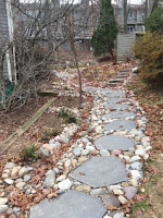
To try to protect the quality of its waters, the Commonwealth of Virginia encourages property owners to engage in best practices to reduce the quantity of stormwater that leaves your property and to improve the quality. As an incentive, the Northern Virginia Soil & Water Conservation District (SWCD) offers grants for approved projects proposed by HOAs, civic organizations, religious institutions, and individual property owners. In 2020 Lakeport qualified for two grants to install a rain garden and conservation landscaping between 1952 and 1954 Lakeport Way. The rain garden has successfully captured runoff from four downspouts, but unfortunately surface-level runoff is still causing erosion between 11110 and 11112 Lakespray and mud between 1952 and 1954 even after the owners paid to install rock steps so they could safely reach their back patios.
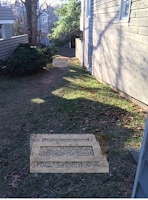
In addition to controlling and minimizing runoff and conserving that water within the landscape, the infiltration steps will make it safer for contractors and anyone else going down that hill, although its use as a route to Lakeport Way (or for sledding/skiing 😊) is discouraged. The placement of these steps will also encourage anyone walking there to do so on common property rather than on private property.
Installation of the steps is contingent on final approval by RA’s Design Review Board and approval of a $3,500 grant from NoVA SWCD that would cover most of the cost.
Note that if you have stormwater issues, you might want to investigate applying for your own grant from NoVA SWCD to fund one of their best practices (e.g., a rain barrel, conservation landscaping, or a dry well). See https://vaswcd.org/vcap for more details and links to eligible practices.
No comments:
Post a Comment